Citizens taking action to monitor river flood threat.
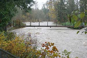
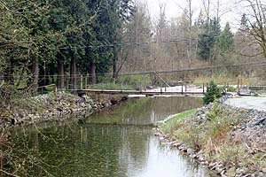
Residents in the Alouette Valley area of Maple Ridge, B.C., have noticed during recent storms how dramatically the river levels fluctuate. Several recent incidences prompted some residents to take emergency action to deal with potential flooding.
No one knows for sure what is causing this. Development, river management neglect, La Niña and climate change are some of the reasons given for the recent, extreme river fluctuations. The District of Maple Ridge plans to spend $65,000 on a study to find out, but this will be of little help in the short term.
The river gauge project is one of several initiatives that citizens are taking to mitigate the risk. The intent is to provide residents who are at risk of flooding with an early warning system so that property owners may take action, such as moving livestock to higher ground, sandbagging and other preventitive measures. The gauge project will also collect valuable data for future analysis.
Statistics are updated in near-realtime using non-invasive (salmonid safe) techniques and sent remotely to this Web site, available publicly to all those concerned.
If you have any questions or comments about this project, please contact us.